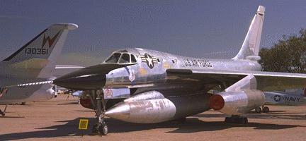
Photo by John Sepp. Courtesy of the Pima Air and Space
Pikes's Peak B-58 Hustler
|
| One of history's most elegant airplanes.
Photo by John Sepp. Courtesy of the Pima Air and Space |
| Name | Pikes Peak B-58 |
| CAP data | 38d 49 m 105d 03m |
| GPS coords | |
| UTM | |
| Datum used | NAD 27 |
| County |
Date: 22 April 1960
A/C tail number 58-1023
The wreck cause: Loss of control during normal flight due to Mach/airspeed/air data system failure.
Casualties: Ray Tenhoff, Convair pilot
Walter Simon, Convair flight test engineer
Survivor: Kenneth Timpson, Convair flight test engineer
Site Description:. CAP says "South of Pike's Peak"
B-58 webpage says "24 mi NW of Ogden UTAH" (Check for yourself)
Analysis: 39.82 105.05 vs. 41.49 112.27 It's hard to understand how even a typo could have put down the wrong coordinates. Perhaps it's just a complete and utter mis-entry in the CAP database???
Home Moggie!
Last Modified: 1/1/2008