ELK MOUNTAIN DC-3 CRASH SITE
BACKGROUND: The Crash
Jan 31, 1946 United Flight 14, a DC-3 aircraft enroute from Salt Lake City to Cheyenne, Wyoming at an assigned altitude of 11,000' crashed on Elk Mountain Wyoming. There were 21 fatalities.
The accident report described a following United flight observing UA 14 diverging slightly south on the airway east leg from Sinclair. The trailing flight also reported an orange flash in the dark about 3 miles to the south. That was the end of UA 14.
The wreckage was found on a direct line between Sinclair (SIR) radio range and the Laramie radio range (LAR). The approved airway for the area was actually a dogleg connecting the east leg of Sinclair to the north leg of Laramie in order to skirt around the 11,152' bulk of Elk Mountain.
The accident report did not outright state it but the conclusion this author draws is that the flight did not follow the dogleg range legs but, instead, used the ADF to track directly from Sinclair to Laramie. This would have worked out if the flight had been at 13,000' as originally filed rather than at 11,000' as requested en route.
The impact site was at 10,700 MSL. (according to the report. More like 10,900 by altimeter and GPS)
In computer simulation this author has conducted, it seems that there is a 30 second window after passing SIR (Sinclair beacon) where taking a course for LAR(Laramie beacon) results in ground contact. Turning earlier or turning later winds up missing the mountain.
BACKGROUND: Preparing to Search
I enjoy finding old airplane wrecks. I get a kick out of the history, the technology, and the hiking. I'm not salvaging nor scavenging but am providing the GPS coordinates back to CAP and on some wrecks, posting the coordinates for others to enjoy.
This wreck was listed on the Wyoming State Civil Air Patrol list of known wrecks. From previous experience (16 other sites located), coordinates from CAP have significant error and are insufficient info to justify a long hike. (think of how far off a 5 mile error is in 10,000' mountains!)
Using various net and personal resources (Thanks to Duke Sumonia of Estes Park) I collected newspaper clippings and the official accident report to gain additional clues. In this case, the accident report indicated an impact altitude of 10,700' (an excellent search narrower), a furrow in the snow 200 yards long and that on impact one engine was thrown ahead and over the other side of the ridge.
Map and driving reconnaisance revealed that Elk Mountain is a patchwork of Bureau of Land Management land but that access to that BLM land required crossing private property- the Elk Mountain Ranch. (henceforth referred to as EMR)
In March I contacted Peter Thieriot, the owner of EMR, in order to request his permission to search for this wreck as well as another (an A-20 medium bomber, crashed 1942).
Peter has owned the ranch about 6 years and is very interested in the history of the ranch and mountain. Peter was amenable to the search so I sent him copies of everything I'd gathered so far and we agreed that I'd call him in July when access to the mountain was possible after the snow drifts melted.
July 1999
I called Peter on Tuesday , 13 July, and inquired about road conditions on the mountain. He said the roads were open to low ground pressure vehicles (ATVs) and that the coming weekend would work for him.
We agreed to meet on Sunday, 18 July at ranch HQ at 0900. Peter was amenable to having Dale Hueske (Dale's website ) join us in the search and when Dale got the news I think I heard the 'Yippee' all the way to Colorado.
So I advised Dale as to what I thought would happen and what equipment might be needed for personal comfort - water, raingear, etc
THE SEARCH, Part I
Sunday, 18 July.
0445 Reveille. (ugh) It is about a 2.5 hr drive from Ft. Collins to Elk Mountain.
0550 Underway from Ft. Collins CO. (not much traffic for some reason)
0810 I reach the Elk Mountain exit on I-80 looking for Dale. I saw nothing on the south side exit but spotted Dale's truck at the gas station on the north side. Dale was busy pumping the gas station guy for info and I joined in on the discussion. The most notable info is that the fellow said an airplane engine had lain in the weeds at that gas station for many years but wasn't there now.
0830 We leave the gas station and begin the slow drive from the EMR entrance at the county road. The ranch has a 15 mph speed limit and Peter had emphasized it to minimize road washboarding. We took our time and enjoyed the scenery seeing antelope lying in the grass alert but undisturbed by our passage.
0900 We arrive at ranch HQ and go find Peter and introduce ourselves and generally get ready to go. Peter is providing the group with transportation in the form of 2 John Deere "Gators" (6WD ATV), and Honda Foreman 4WD ATVs. Peter is very concerned about past deterioration in the habitat of the mountain and takes great pains to let the area reahabilitate itself. This includes reducing vehicle traffic to ATVs which leave nearly no sign of their passage due to their low ground pressure.
The cast includes: Peter, Dale, Christine (sister-in-law), X (nephew), Y (another nephew), Jerry and (??)
0930 We set off to the west following a dirt ranch road. Dale is sitting beside Peter on one of the Gators and it's obvious he is getting the story on the ranch. Meantime I am trying to cope with the familiar yet unfamiliar controls of my ATV. I have 20 years of motorcycling reflexes that need to be carefully checked. The ATV has many similarities but several differences that require my full attention.
1030 After much great scenery and driving right around a sign that said "No Vehicles Beyond This Point" we break out above treeline and drive up to the side of a ridge.
As I park my ATV and shut down I spot a green copper item near my left foot. I expected it to be a US penny since there was a road track here and a Univ. of Wyo building on the ridge but upon inspection this turns out to be a Chinese coin. No English at all! The Japanese coins I've collected on trips in the last decade at least have some English.
I gave the coin to Peter and looked some more but found no more.
We debated whether GPS altitude could be trusted and compared it to the altitude on my Casio altimeter watch. Being unsure, the question was resolved by Peter noting the altitude of the very nearby summit and my taking my ATV up there and recalibrating my watch.
I came back and we descended to where I determined 10,700' should be.
1045 After getting ourselves sorted out with packs, water, radios and a plan to walk line abreast along the 10,700 contour we set out.
1047 In 2 minutes I found a piece of airplane skin and aluminum tubing at my feet.
Within 10 minutes others had found another half-dozen widely scattered bits including a chunk of exhaust stack way, way far down the meadow and a piece of olive-drab painted aluminum. It was clear that these were indeed airplane parts but the wide, sparse distribution really bothered me. There was no particular reason for these parts to have been naturally displaced from anywhere (via water or wind) and they were very few and fairly small.
Jerry had followed some stacks of rocks down the meadow and it seemed possible that the trail markers would lead down the hill to a wreck.
I hiked quickly down the hill and lost the markers. I cut back and forth without finding any more. I finally arrived at a theory that perhaps we were looking at a place where small parts had fallen off the clean-up truck.
On this theory I walked further downhill on the grassy ridgetop where an Army 6x6 truck could reasonably have driven. Sure enough, I found another piece of airplane in the grass even further down.
Near the end of the grassy portion of the ridge, a very narrow vehicle trail descended the ridge directly downwards.
There are two historic wrecks on this mountain, the DC-3 and an A-20 (DB-7) that crashed in 1942. It seemed possible that we might be looking at A-20 parts that could have been brought up from below.
I started hiking quickly down the hill on the road hoping to see more airplane parts. I figured that if the truck were dribbling parts I could find them on the road and maybe the road would lead to the actual crash site like for the C-46 on W. White Pine Mtn.
I descended about 600' without seeing another part. The rest of the group followed me down the hill a very short ways (I know this from the radio) and I overlooked a small aluminum rib but they found no further.
Via radio the rest of the party heard my plan and eventually collected some of the ATVs and followed me down the hill. I had missed a single very slim piece of ribbing that was underneath a square aluminum tag affixed to a tree. But there were no more parts.
As the ATVs came down the trail, they turned around and I got a ride back up to the meadow where we sat in the shade and ate lunch while pondering what we'd seen so far.
After lunch Peter suggested we head back to where the first parts had been found and fan out from there.
1500 This we did. After perhaps 30 minutes of wandering Peter and I converged on the 2 track road and talked. Peter was thinking about the cleanup truck theory and I had suggested that maybe the trucks went DOWN that road if the way we'd come up were too recent.
This stimulated him to ponder where the trucks could have been coming from. On this, he started walking east. I took spacing on him and walked parallel.
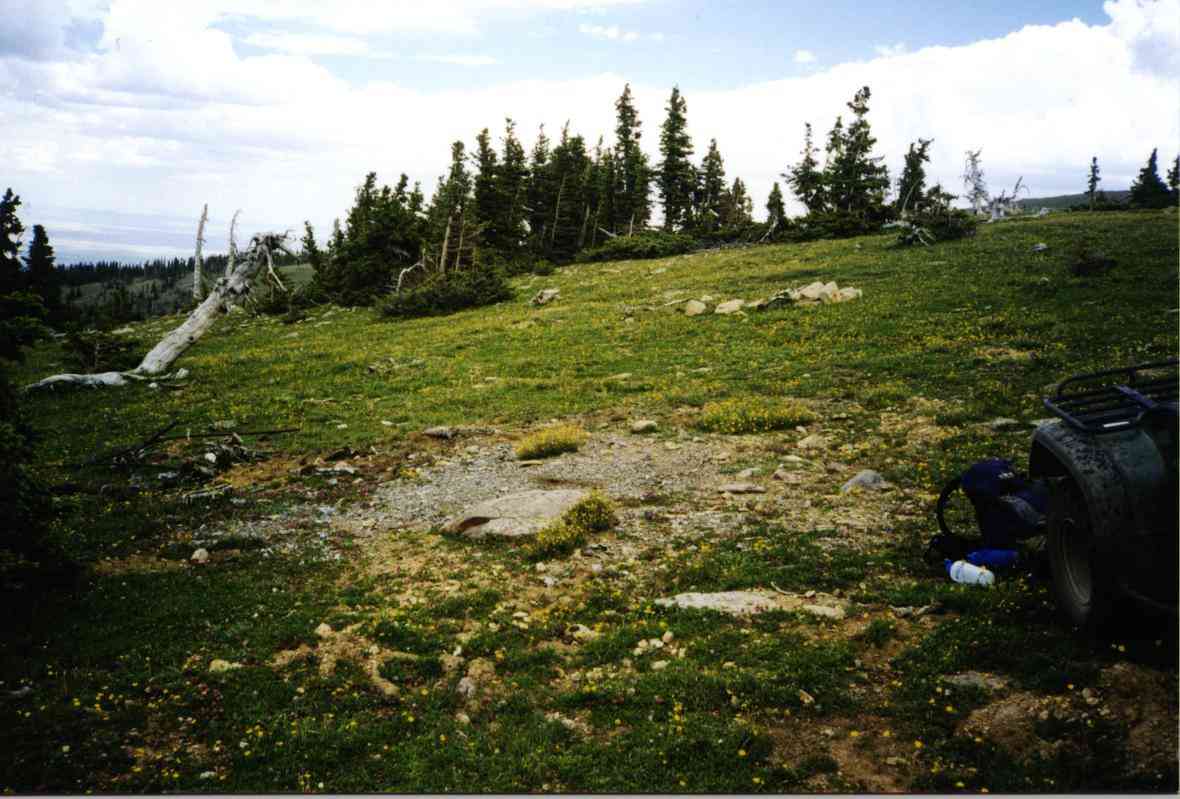
1530 In about 5 minutes we came to a burned spot with melted aluminum and airplane parts. We called the others over (via radio and whistle) as we pondered what we were looking at. There were clumps of melted aluminum and bits and pieces but nothing bigger than one's hand.
Further east was another burned/melted spot with no more identifiable parts. It was interesting that there were no parts between the initial find and the burned spots.
(Click on the pictures to get enlarged images)
|
|
|
| Melted aluminum | Different spot. Melted aluminum. | Another spot, melted aluminum |
Summary: The wreck had been 99.5% cleaned up (no engines, no landing gear, etc) and the parts we'd found initially probably fell off the trucks as the mess was being taken away. After an hour of looking, sifting, and wondering we'd had enough time to see that there was little identifiable as to what kind of airplane had crashed here. There was no way to know if it was a DC-3 or an A-20.
I assumed it was a DC-3 since the elevation matched the accident report.
1530 Back at the ranch we turned in the ATVs, took off our packs, changed shoes and relaxed from the trip. I quickly paged thru my photo albums of other wrecksites to show everyone how sometimes there is wreckage....
1830 Dale and I then headed east on I-80 to Laramie where we had dinner and I could show him the pictures in greater detail.
2100 With regret, we finally parted to go our separate ways. I had a 90 minute drive home thru deer country (US 287) while Dale went to Cheyenne for a motel and then the next day to go all the way home to Kansas.
THE NEXT SEARCH (Part II)
I contacted Sherman Johnson, an Elk Mtn local who I'd originally gotten some info from to see if he could enlighten me further now that I'd been on the mountain. Sherman described TWO wrecks within 1/4 mi and 500' elevation of each other. "So close they might be the same wreck. In the Brush Creek drainage. Maybe 10,000 feet elevation"
On Saturday, 24 July, with Peter's blessing, I went back up to search again. This time it was just me and a loaned ATV.
1030 I returned to the previously found sites and used my recently-repaired video camera to take pictures. I also took a lot more 35mm pictures.
1100 I descended down the meadows to the top of the grassy ridge where we'd eaten lunch last week and parked my ATV. Thinking "in the drainage, in the trees, down about 500'" - I hiked down the hill opposite the narrow road of last week. I zig zagged thru the trees and crossed the creek and zig zagged up the other side. No airplane parts. The only man-made item I found was a very old rusty metal bucket in the creek.
1200 Back at the ATV I had lunch and thought awhile. There was yet another patch of woods uphill from here in a saddle between two balds of the ridge.
1230 I drove the ATV back up the ridge to the opening where where the first parts had been found. Then I went back to the road and uphill. I was thinking I'd ride the shoulder of the ridge up and over to get to the other patch of woods. A 2-track road/trail diverged from the familiar road so, since it was going the right way, I took it. About 100' up the hill I spotted a small tangle of rusty metal.
Hey! Here's MORE!!!!
 |
 |
| 2nd trip, more melted metal | UA 14 crash track into the camera |
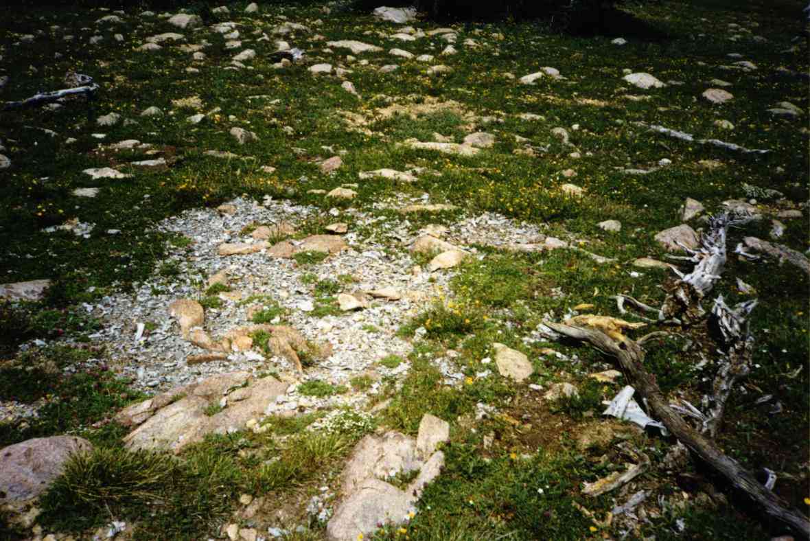
There was another melted aluminum/burned spot not 5 feet from the track.
On further exploring, I found melted aluminum IN the track and another burned spot about 100 feet east. I note that this is almost perfectly level with the spot on the hill about 200 feet away where I found the Chinese coin.
Going backwards to the west I could find a very sparse debris trail (1"x2" pieces occasionally) into a few small trees where there are fragments of blue and white china. THIS must be the DC-3!
Well, if this is the DC-3 then are the other burns , 0.22mi away by GPS, also DC-3 or not?
I took video and photos but never did find any identifiable parts. More little bits of screws, nuts, blobs and things.
I walked all the way to the Chinese coin spot looking. Perhaps every 20 feet or so would be another tiny scrap. But one had to look very closely to find them.
This also had to be the ridge where the report said one engine had been thrown over.
1330 I'd had enough here and thought that maybe the wooded basin might be worth a look so I took the ATV up the ridge, past the weather house, and down the other side to the saddle. After about 20 minutes in untouched elk country, I decided there was no reason to look here.
I went back up the ridge and down looking for a place to leave the ATV to hike the creek looking for the missing engine.
1430 As I parked the ATV I was joined by Jerry, Peter's cousin from France. Together we hiked the creek basin to the east of the site looking for an engine that might have been too heavy or awkward to move.
No luck. We found several University buildings in the area and easy terrain around including a good road. Chances are that the engine was recovered.
1530 I took Jerry to the new sites so he can show Peter. I worked west and picked up some of the china shards. I worked east and in the grass next to one burn I found a .... GUN! It turned out to be a plastic cap gun in perfect condition. Made in Hong Kong, it couldn't be from the DC-3 period. Must have been some tourist who'd visited in the past. I picked that up too.
1730 Back at the Elk Mtn Ranch I turn in my ATV, bagged the shards and cap gun and wrote Peter a note to go with them.
Summary: How many airplane wrecks do those burned spots represent????
If it's just the DC-3, then where did the A-20 crash?
Who can provide info on the A-20?
Without directions to the A-20, there's little chance of finding it.
I bet Peter will be asking around !
Home Moggie!
Last Modified: 1/1/2008